Fire Teams in Oregon and Washington Receive High Tech Assistance from the Colorado DFPC
Colorado is a state that has a great deal of experience fighting wildfires. It also has some advanced resources for making that challenge more manageable. Colorado’s Division of Fire Prevention and Control (DFPC) sent one of its two Multi-Mission Aircraft to Oregon and Washington this summer, providing an impressive array of technology to support firefighting efforts.
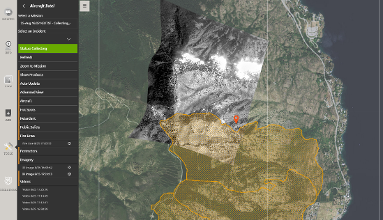
To make the technology accessible, the DFPC also provided access to the cloud-based mobile mapping software that immediately displays infra-red and color imagery sent directly from the Multi-Mission Aircraft (MMA).

Valuable Assets for Situational Awareness
While fighting wildfires on any terrain is hard work, battling them on steep mountain slopes and in secluded valleys is especially difficult. Knowing what you’re up against quickly can make all the difference. Consequently, Colorado has invested in some of the best situational awareness assets available. To detect and definitively locate wildfires before they grow too large to control effectively, the state uses:
- 2 Multi-Mission Aircraft (MMAs) that can get anywhere in the state within an hour.
- SituationAnalyst software configured for Colorado’s wildland and WUI firefighting needs into a system Colorado calls COWIMS—the Colorado Wildfire Incident Management System.
Multi-Mission Aircraft
Colorado’s two MMAs are outfitted with state-of-the-art color and infra-red sensors plus software that the Mission System Operator uses to draw fire perimeters as well as to note other important fire and emergency features detectable from the air.
The MMA flies high above the fires in the heat of the day to detect, through the smoke, what is happening on the ground, and provide key information to incident commanders while their teams are deployed.
Fire perimeters, active fire lines, and hotspots can be seen through smoke with the infra-red sensor and noted in the system. The locations of the features are then communicated quickly and clearly to firefighters logged in to COWIMS.
COWIMS—SituationAnalyst for Colorado
COWIMS delivers imagery in very near real-time to computers and mobile devices to ensure that firefighters, dispatch, and command centers are all getting the same common operating picture at the same time.
Conclusion
The combination of MMA imagery viewed in COWIMS and many other relevant layers of information (such as wind direction and speed, weather, fire history, locations of available resources, MODIS satellite data on hot spots, etc.), gives accurate, up-to-date information to decision makers in the heat of the fight.
“When Colorado needs help to fight wildfires in our state, we rely on other states to send resources,” said State Fire Director Paul Cooke. “We were fortunate that Colorado’s wildfire season has been fairly light thus far,” said Cooke, “so we can afford to help out others with their needs.”
Curious if SituationAnalyst is the right choice for your needs? Check out the benefits here or contact us to talk to an installation specialist today!
